![]()
Bird Island Pier - Table of Contents ................Buffalo Waterfront - Table of Contents
Bird Island Pier -
Group 1 (includes
Ferry Street Lift Bridge)
Buffalo, NY
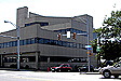
At I-190, head south toward Buffalo. Exit off Ontario Street and turn right onto Niagara Street. Take a right on Ferry Street to access the Bird Island Pier, a popular fishing area.
Broderick Park, the Bird Island Pier and the International Railway Bridge are located on Squaw Island, which separates the Black Rock Canal and the Niagara River at the foot of West Ferry Street, off Niagara Street. Cross the Ferry Street lift bridge over the canal, and park to the right.
TEXT (Beneath Illustrations)
|
|
|
|
|
|
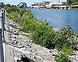
To reach the Bird Island Pier, head west on West Ferry at Niagara Streets |
|
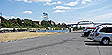
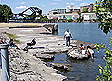
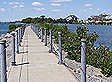
View from the Squaw Island parking lot looking south |
|
|
|
|
|
|
|
|
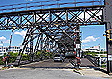
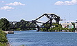
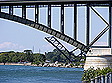
The Ferry Street Lift Bridge as seen from the Bird Island Pier looking north |
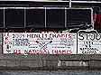
Graffiti was created by West Side Rowing Club high schoolers. |
|
|
|
|
|
|
|
|
|
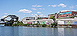
Ferry Street Lift Bridge seen under the Peace Bridge |
|
|
|
|
|
|
|
|
|
|
|
|
|
|||
|
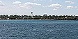
Fort Erie, Ontario, across the Niagara River |
In 1825, New York State passed legislation (Chapter 277) for Erie Canal Commissioners to build canal from Squaw Island to Buffalo Creek. The Bird Island Pier would carve out the canal from the rapidly flowing Niagara River.
Bird Island Pier
P. M. Eckel, Botanical Notes on Squaw Island, Niagara River (online June 2014)
The southern tip of Squaw Island is connected to a long, narrow stone pier that extends south or upstream from the Island, under the Peace Bridge and into the mouth of the Niagara River, or the northeastern corner of Lake Erie (across from Fort Erie, Ontario, Canada). This pier (presently called the Bird Island Pier), although rebuilt and extended southward in the Twentieth Century, was in existence in 1860.
"Vessels driven by storms and failing to gain an entrance to the [Buffalo] harbor find a capacious and sheltered retreat in the harbor of Black Rock, formed by a mole [Mole: A massive, usually stone wall constructed in the sea, used as a breakwater and built to enclose or protect an anchorage or a harbor] from Bird Island to Squaw Island, a distance of 2915 yards. [Ed. note: emphasis in bold added to emphasize the historical difference between the two islands that are now connected as one.]
This, with the islands, forms a harbor 4,565 yards long and from 88 to 220 yards wide, with an area of 136 acres. Besides affording an exceedingly convenient harbor, with an average depth of 15 feet, this work secures a water-power of about 4 1/2 ft. A ship lock is constructed at its foot; and it is on the line of the Erie Canal." (French, 1860 p. 284).
Black Rock Channel
US Army Corps of Engineers (online June 2014)The Black Rock Channel extends from Buffalo Harbor to the Black Rock Lock. The waterway is 3 and 1/2 miles long and its navigation channel is at least 200 feet wide at all points. The lock and channel permit pleasure craft and commercial vessels up to 625 feet long with drafts up to 21 feet. The passage of commercial vessels is scheduled by radio from the Black Rock Lock.
The channel is crossed by three bridges: the Peace Bridge, the Ferry Street Bridge and the International Railway Bridge.
- The Peace Bridge, located 1.3 miles from the south entrance to the channel is a fixed bridge with a clearance of 200 feet above Low Water Datum* (LWD).
- The Ferry Bridge is located 1.9 miles from the south entrance. It is a lift bridge that has a clearance of 17.3 feet LWD when down.
- The last bridge before the lock is the International Railway Bridge, 3.1 miles from the south channel entrance. It is a swing bridge which has a clearance of 17 feet LWD when closed.
The Bird Island Pier and Black Rock
Excerpt from Historic Old Black Rock, by Austin M. FoxHistoric Black Rock, however, extended from School Street, which runs into Niagara near the Peace Bridge, to about as far as Austin Street, which is beyond the International Bridge to Canada. Old Black Rock's western border was the Niagara River and its eastern line was approximately the eastern boundary of the Mile Strip. New York State had bought this mile-wide swath from the Seneca Indians in 1802 and shortly afterward sold lots on this land. North of where the Scajaquada Creek empties into the Niagara River near Tonawanda Street and Forest was called Lower Black Rock, and the area south of that creek mouth was termed Upper Black Rock.
The black rock itself from which the locality took its name lay in the river just north of the Peace Bridge. It was a large triangular shelf of darkish limestone that jutted about 200 feet from the shore and rose four or five feet above the water. It was river-current-sheltered and an ideal docking place for boats and for the oar-propelled ferry across to Canada.
But the black rock was dynamited away in the early 1820s to make way for the Erie Canal bed that paralleled the shore and proceeded via the Buffalo River to Buffalo Harbor.
The commercial and social center of Black Rock at that time was the Niagara Street, Breckenridge and West Ferry vicinity - about where the Rich Products complex lies today. After the removal of "the rock," the ferry operated from Squaw Island at the foot of West Ferry Street.Buffalo annexes Black Rock
Because of the superiority of Buffalo harbor to the one at Black Rock, the commercial centrality of the region shifted to the Port of Buffalo. Black Rock lost more of its identity when it was annexed to the city of Buffalo in 1854. But industry along Niagara Street continued for some time. The Thomas Flyer Company, for example, made early automobiles and then Curtiss Jenneys during World War I and Curtiss dive bombers during World War II.
Additionally, the Bird Island pier remained for some time a place for boarding the pleasure steamers en route to the resorts on Grand Island. Squatters settled along the canal towpath, but the state dispossessed them when it built the New York State Thruway extension. Today riverboating, fishing, and the picturesque recreational activities of the West Side Rowing Club still continue, reassuringly.
The Bird Island Pier
Excerpted from The Buffalonian (online June 2014)"Another effect of the decision of the [Erie] Canal Commissioners [deciding where the terminus of Erie Canal should be] was to encourage the people of Black Rock to apply to the Legislature for immediate legislation and an appropriation for the construction of a harbor at Black Rock upon a plan proposed in the report of James Geddes under date of February, 1821. They were successful, as evidenced by the passage on April 17, 1822, of an act 'To authorize and encourage the construction of harbors of Buffalo Creek and Black Rock,' known as Chapter 251 of the Laws of 1822.
By this act, there was appropriated $12,000 for a harbor at Black Rock, and the Canal Commissioners entered into a contract, in 1822, with Peter B. Porter and Sheldon Thompson, who were authorized so to do by the citizens of Black Rock, for the construction of 530 rods of mole or pier to connect Bird Island and Squaw Island, and 30 rods to unite the latter island with the main land.
The pier was to be 16 feet in height and 18 feet in width. They were also to construct 260 rods of embankment along the eastern shore of Squaw Island, which was to be 30 feet broad at the base and 6 feet at the top. They were also to construct a towpath two miles and 27 chains in length on the easterly side of the harbor and a lock between the harbor and the river. The contract price for this work was $83,819, which included the Black Rock appropriation of $12,000. As the pier was constructed there was some apprehension that it would be carried away by the storms of Lake Erie, or by the fields of floating ice in the springtime.
1812 map shows a division between Squaw Island and Bird Island.