![]()
Neighborhoods
in Buffalo, NY - Links
On this page:
Black Rock and Riverside Riverside Park Historic District
Architecture links - Black Rock and Riverside
Architecture/History - Grant-Ferry-Forest Neighborhood: Intensive Level Historic Resources Survey
History - Grant / Amherst by James Napora. Includes histories of 8 houses of worship
History - Riverside by James Napora Centers on the intersection of Tonawanda and Ontario Streets. Vulcan Street runs along the northern edge of this area of Northwest Buffalo. Includes histories of 8 houses of worshipArchitecture links - Downtown
Niagara Square Photos, history, architectural analysis.
Cobblestone Historic District
Joseph Ellicott Historic District
Theatre Historic District
History - Downtown Buffalo by James Napora Centers on Main Street from Goodell Street to the Buffalo River. Within this two mile area are three separate centers: the Theater District in the north, the civic and commercial center around Niagara and Lafayette Squares, and the Waterfront area at the south end. Includes histories of 9 houses of worship
Hamlin Park Local Historic District
Hamlin Park
Martin Luther King Jr. Park Historic District
Martin Luther King, Jr. Park
History - African-Americans and the East Side by Mark Goldman Centers on the residential area north of Martin Luther King Jr. Park.
History - Humboldt Park by James Napora
History - Hydraulics by James Napora. Includes histories of 10 houses of worship
History - Fruit Belt by James Napora Centers on High Street, with the "33" (Kensington Expressway) enclosing the southern boundary of the Fruit Belt. Jefferson Avenue runs along the East Side, but it is Grape, Peach, Orange, and Lemon Streets that gave the name to the district. . Includes histories of 7 houses of worship
History - Germania I by James Napora. Includes histories of 14 houses of worship
History - Germania II by James Napora. Includes histories of 10 houses of worship
History - Germania III by James Napora. Includes histories of 13 houses of worship
History - Germania IV by James Napora. Includes histories of 12 houses of worship
History - Germania V by James Napora. Includes histories of 12 houses of worship
History - Kaisertown by James Napora Centers on Clinton Street and is physically enclosed by the Buffalo River on the south and the Thruway 90 on the northwest.
History - Lovejoy (Iron Island) by James Napora. Includes histories of 9 houses of worship
History - Lower East Side by James Napora
History - Polonia by James Napora Centers on Broadway, which runs through this historic Polish-American area. Fillmore Avenue runs along the western edge, and is part of the larger East Side of Buffalo. Includes histories of 12 houses of worship
History - Cold Springs by James Napora Centers on Michigan Avenue close to the intersection of Main Street and East Utica Avenue. Includes histories of 13 houses of worship
History - Babcock Neighborhood by James Napora. Includes histories of 5 houses of worship
History - 'Buffalo Doubles': Industrial Vernacular Style by Gregory Stein
History - History of African-Americans in Buffalo, NY
Photos - Broadway / Pratt Area by Stephen CorbettArchitecture links - Kensington / Bailey
History - University Heights by James Napora. Includes histories of 8 houses of worship
Centers on Main Street from Niagara Falls Blvd. south to LaSalle Avenue.
History - Bailey-Kensington Area From Buffalo Architecture: A Guide
History - Bailey/Kensington North by James Napora Kensington: Centers on Kensington Avenue from Main Street to the city line at Cheektowaga. Bailey Avenue is an important north-south street in the neighborhood. The "33" (Kensington) Expressway cuts this large district in half. Includes histories of 12 houses of worship
History - Bailey/Kensington South by James Napora. Includes histories of 7 houses of worshipNorth Park and Parkside and Central Park
History: Francis R. Kowsky, North Park and Central Park
Boundaries: Parkside, Central Park, and North Park
Central Park: Architecture links - Central Park, North Park and Parkside
Central Park: James Napora, History of Central Park and Parkside Includes histories of 11 houses of worshipCentral Park: Lewis J. Bennett / Central Park History
Central Park: Depew Avenue
Central Park: Morris Avenue
Central Park: Otowega Club
Central Park: Central Park United Methodist Church
Central Park: Parkside Lutheran ChurchCentral Park: Belt Line Railroad Amherst/Starin Station
Central Park: Two 1894 The Buffalo Courier articles found on Fulton History (online October 2021)
Central Park: Two October 3, 1892 Buffalo Courier reprints found on Fulton History (online October 2021)
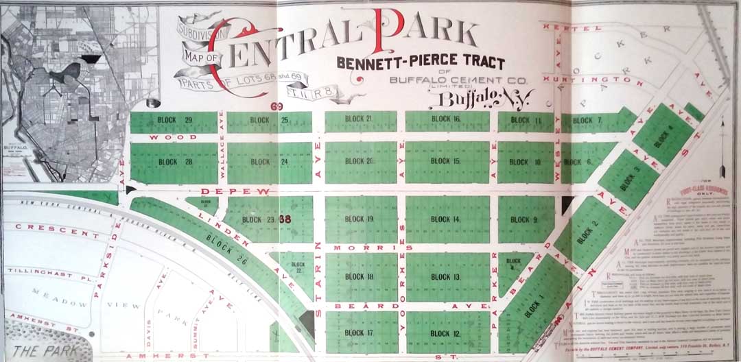
Central Park: 1892 map: Central Park, Bennett-Pierce Tract
Central Park: A Sampling of Homes
Central Park: Demolished Buildings----
North Park: North Buffalo Boundaries
North Park: Architecture links - North Park, Central Park, and Parkside
North Park: James Napora, History of North Park Includes histories of 14 houses of worship
North Park: Gregory Stein, 'Buffalo Doubles': Industrial Vernacular Style
----
Parkside: Architecture links - ParksideParkside: James Napora, History of Central Park and Parkside Includes histories of 11 houses of worship
Parkside: Anne Putman, History of Parkside
Parkside: Parkside Community Association, History of Parkside (online May 2017)
Parkside: Living Places: Parkside West Historic District Nomination Excerpts (online May 2017)
Parkside: Living Places: Parkside East Historic District Nomination Excerpts (online May 2017)
Cazenovia Park - South Park System - Table of Contents
Triangle Neighborhood Historic Resources Intensive Level Survey Boundaries: Cazenovia Creek / Amber Street / South Park Avenue and Southside Parkway / Hopkins Street, Lilac Street, and the former Delaware, Lackawanna & Western Railroad line. On City of Buffalo Website
Architecture links - Waterfront
History -'Buffalo Doubles': Industrial Vernacular Style by Gregory Stein
Photos - Canal District 1910-1925 from the collection of Ronald R. Dukarm
History - First Ward and the Valley James Napora First Ward: Centers on South Park Avenue. The I-90 Thruway runs along the northern side, and the Buffalo River forms the southern boundary of this industrial district.
Architecture links and History - Grain Elevators
History - South Buffalo - Seneca Street by James Napora. Includes histories of 7 houses of worship
History - South Buffalo - South Park/Abbott Road by James Napora. Includes histories of 15 houses of worship
Architecture links - South Buffalo and South Park South Buffalo: Centers on the area south
Cazenovia Park - South Park System - Table of Contents
Triangle Neighborhood Historic Resources Intensive Level Survey Boundaries: Cazenovia Creek / Amber Street / South Park Avenue and Southside Parkway / Hopkins Street, Lilac Street, and the former Delaware, Lackawanna & Western Railroad line. On City of Buffalo Website
Architecture links - Waterfront
History -'Buffalo Doubles': Industrial Vernacular Style by Gregory Stein
Photos - Canal District 1910-1925 from the collection of Ronald R. Dukarm
History - First Ward and the Valley James Napora First Ward: Centers on South Park Avenue. The I-90 Thruway runs along the northern side, and the Buffalo River forms the southern boundary of this industrial district.
Architecture links and History - Grain Elevators
History - South Buffalo - Seneca Street by James Napora. Includes histories of 7 houses of worship
History - South Buffalo - South Park/Abbott Road by James Napora. Includes histories of 15 houses of worship
Architecture links - South Buffalo and South Park South Buffalo: Centers on the area south of the Buffalo River. A large district, it extends to the Lackawanna city line on the south; to South Park Avenue on the west; and to the eastern side of Cazenovia Park on the east.University Heights
Architecture links - Elmwood Village Museum District
Architecture links - West Village
Architecture links and History - Forest Lawn Cemetery
Architecture links - West Side
Allentown Historic District
Delaware Historic District
Front Park - LINKS
Linwood Historic District
Linwood Avenue Building Permits List
History - Allentown / Main / Linwood / Delaware James Napora Allentown: Centers on Allen Street, from Main Street to Symphony Circle. It is adjacent to the Theater District of downtown Buffalo on the south and is bordered by North Street at its northern edge.
History - Delaware Avenue Historic District from National Register of Historic Places Nomination
History - Grant / Amherst James Napora. Includes histories of 8 houses of worship
History - Richmond /Elmwood Area James Napora. Includes histories of 13 houses of worship
History - The Allure of Linwood by Anthony Chase
Architecture links and History - Linwood Avenue Houses
History - Little Summer Street by Mark Goldman
Architecture links and History - Millionaires' Row
History - Soldiers Circle, Bidwell Parkway and Chapin Parkway by Benedict R. Maryniak
History - West Side, Lower by James Napora West Side: centers on Grant Street and is one of the largest neighborhoods by area in the city. The West Side runs west from Elmwood Avenue to Lake Erie and north from Porter Avenue to Buffalo State College
Lower West Side: Centers on Niagara Street from City Hall to Porter Avenue.
History - West Side, Upper by James Napora. Includes histories of 7 houses of worship
See also: A Short History of Buffalo by Susan M. Pollack
